- 01843 834160
- [email protected]
- Mon - Fri: 9:00 - 17:00

A Sign Of The Times – New-Look Visitor Information Boards in White Cliffs Country
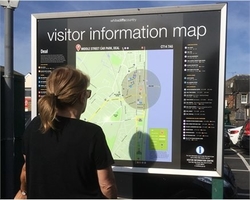
Twelve eye-catching new visitor information maps have gone up across White Cliffs Country, with a colourful design showing details of local attractions, including journey times for walking or driving.
The new modern-look maps have been printed and put up to replace the older style maps on boards in prime car park locations and other sites across Dover District. Each of the maps is tailor-made for the location in which it is sited, and features a marker showing where you are, a circle showing what’s within a five minute walk, and journey times to a range of other key attractions in the town or the local area.
The boards show a range of information on attractions for visitors, including castles and forts, historic sites and buildings, unique countryside and gardens, leisure and activities, theatres and cinemas. There’s also information on the surrounding area, villages and countryside, and a range of useful information including locations of local bus and train stations, police stations, council offices, libraries, and hospitals.
Four of the boards are also double-sided, with the reverse side showing details of great days out across the whole of White Cliffs Country, taken from the popular new Days Out leaflets.
Cllr MJ Holloway, DDC Cabinet Member for Community and Tourism, said: “White Cliffs Country is full of breathtaking scenery and fantastic places to visit, and we are delighted to launch these newly updated visitor information boards, to help people find their way around the district, and to help people discover even more of the many attractions that make the area such a great place to visit.”
For more information on visiting White Cliffs Country, please see the White Cliffs Country website.
You are able to keep up to date with our articles, news and publications by following us on our social media channels below:
![]()
![]()
![]()
![]()
![]()
![]()

News


 Sevenoaks Welcomes Refugees Fundraising Event
Apr 10, 2024

 Thanet District Council grants more than £200k
Mar 25, 2024


 Got The Love Festival: Litter Pick
Mar 13, 2024
 10th Anniversary of The Micro Museum, Ramsgate
Mar 08, 2024